What is MSA-Minimum Sector Altitude?
Minimum Sector Altitude (MSA) is a vital safety feature on instrument approach charts that ensures obstacle clearance for aircraft operating in the vicinity of airports. Especially critical during emergencies, MSA plays a key role in terrain awareness and flight safety during the approach phase.
✈️ What Does MSA Mean in Aviation?
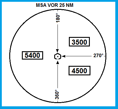
Minimum Sector Altitude (MSA) refers to the lowest altitude that guarantees at least 1,000 feet (300 meters) of clearance over all terrain and known obstacles within a defined sector, typically a 25 nautical mile (NM) radius around a specified navigation aid (e.g., VOR, NDB, or waypoint).
This altitude is depicted on instrument approach procedure (IAP) charts, usually displayed in a sectorized circle divided into 4 quadrants of 90 degrees each, although the segmentation may vary depending on obstacle distribution.
🛫 What Is the Purpose of MSA?
MSAs are designed to provide a quick reference for obstacle clearance when an aircraft is maneuvering in the terminal area, particularly in the following scenarios:
- Loss of navigation capability or situational awareness
- Emergency diversions or missed approaches
- Communication failure
- Need for holding time while troubleshooting
While MSAs help ensure basic terrain clearance, they do not guarantee air traffic separation or alignment with any flight procedure. Therefore, they are not intended for navigational routing or holding patterns.
📌 How is MSA Determined?
The MSA is established by procedure designers in accordance with ICAO or FAA obstacle clearance criteria, and is based on:
- Elevation of highest obstacle or terrain within the sector
- A 1,000-foot buffer added above this elevation
- Coverage of a 25 NM radius around a central fix (typically a VOR/NDB or waypoint)
In some high-terrain or mountainous areas, the Minimum Off-Route Altitude (MORA) or other terrain-based altitudes may offer higher clearance requirements.
⚠️ Clarifying a Common Misconception: Is It Safe to Circle at MSA?
A common misunderstanding is that a pilot can simply “circle” at MSA altitude in case of emergency. While MSA provides safe obstacle clearance, it is not a designated holding altitude, and aircraft should not loiter at MSA unless absolutely necessary.
During emergencies, pilots should:
- Refer to published missed approach or contingency procedures,
- Climb to a known safe altitude (e.g., MEA or MORA),
- Proceed to a nearby fix or hold at a charted holding point,
- Communicate with ATC if possible,
- Avoid circling randomly at MSA unless terrain avoidance is the only concern.
In summary: MSA ensures obstacle clearance, but not procedural navigation or traffic separation.
🗺️ MSA vs. Other Minimum Altitudes
| Altitude Type | Purpose | Clearance | Navigation |
|---|---|---|---|
| MSA | Terrain clearance within 25 NM radius | 1,000 ft above obstacles | Not for navigation |
| MORA / Grid MORA | Off-route terrain clearance | 1,000–2,000 ft | Enroute/off-airway coverage |
| MEA (Minimum Enroute Altitude) | Ensures navigation and communication | Obstacle + signal coverage | Yes, for airway routing |
| MHA (Minimum Holding Altitude) | Holding pattern safety | Varies by location | Yes, holding procedures |
🧭 Final Thoughts
Understanding the role and limitations of Minimum Sector Altitude (MSA) is critical for safe IFR operations. While it provides a valuable terrain buffer in emergencies, it must be used in conjunction with published procedures, controller guidance, and situational awareness.
Whether you’re an airline pilot, flight dispatcher, or aviation enthusiast, knowing when and how to reference MSA could make a critical difference in flight safety.
Recommended Article: Understanding Decision Height (DH) and Decision Altitude (DA) in Aviation
References:
https://skybrary.aero/articles/minimum-sector-altitude-msa
https://www.faa.gov/air_traffic/publications/atpubs/pcg_html/glossary-m.html
https://www.pilotscafe.com/glossary/minimum-safe-altitude-msa/