
The weather is quite clear. You fly with in a calm wind on a beautiful sunny day. Suddenly, there is a hard jolt and you have difficulty keeping the plane straight. Like a feeling of emptiness, it’s a risky jolt that can sometimes scare passengers as well. wind shear…
The change in the horizontal and vertical sudden direction and strength of the wind is called Wind Shear.
HOW TO DETECT AND AVOID WIND SHEAR
It occurs especially at landing and low altitudes. It is one of the most risky meteorological events for aircraft in open weather. Unfortunately, it is difficult to determine the exact location and intensity of wind shear with high precision, beacause it is a dynamic phenomenon. Wind shear predictions are related to wind measurement devices installed at different points in the departure and arrival area. It is gained with the information obtained from some devices. Examples of these devices are Low Level Wind Shear Alerting System (LLWAS) and/or Terminal Doppler Weather Radar (TDWR).
On the other hand, perhaps the most reliable information is the reports provided by the pilots of these double-flight aircraft. A pilot who has experienced wind shears can report wind shears at that moment or after landing. In the pilot wind shear report, it conveys information such as the location, altitude and intensity of the wind shear. For example, “moderate wind shear at the 4 miles on final approach for runway 35 at 400 feet” could be the report of a wind shear situation.
Predictive and Reactive Wind Shear Systems
Modern commercial aircraft typically use both predictive and reactive wind shear systems to improve flight safety during takeoff and landing operations. Predictive wind shear systems use onboard weather radar to detect potentially hazardous wind shear conditions ahead of the aircraft before penetration occurs. Reactive wind shear systems, on the other hand, monitor aircraft performance parameters such as airspeed, vertical speed, and flight path changes to detect wind shear after the aircraft has already encountered it. Together, these systems help pilots respond more quickly and effectively to rapidly changing atmospheric conditions.
Microbursts
Strong wind shears come when there is a thunderstorm. Especially microbursts are dangerous. Microburst occurs exactly below the CB cloud. This air flow moving strongly downwards creates winds that can cause sudden and great damage. In the thunderstorm event, when rain meets a low air mass, it evaporates, which takes latent heat and causes the surrounding air to cool suddenly. The cooled air sinks to the ground and disperses in different directions. Here it creates an unstable and strong wind.
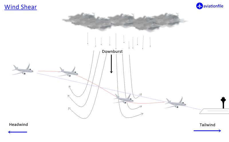
Microburst is of two types as wet and dry. Since wet microbursts occur with rain, radar detection is easier, as in the case we have described. However, dry microbust also evaporates before rainfall, and therefore its detection is much more difficult.
The most violent wind shear is a few feet thick, 80 knots of wind foot and winds with a 90 degree change in direction.
Wind Shear Escape Maneuver
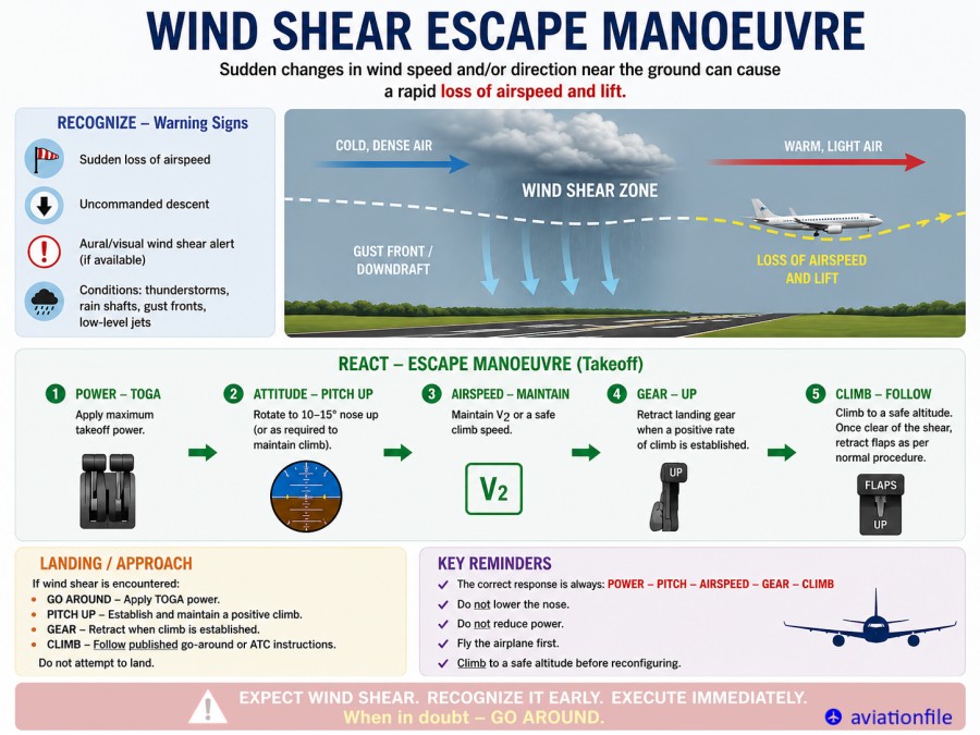
Modern airline procedures include dedicated wind shear escape maneuvers designed to maximize aircraft performance during hazardous wind shear encounters. If severe wind shear is encountered, pilots may immediately apply maximum available thrust and follow specific pitch guidance while prioritizing aircraft performance and terrain clearance. Airline training programs also emphasize that unstable approaches should not be ‘salvaged’ during severe wind shear conditions, and a go-around may be the safest option when aircraft stability or performance becomes compromised.
ATC Role During Wind Shear Events
Air traffic controllers play an important role during wind shear events by relaying pilot reports (PIREPs), issuing runway-specific wind shear alerts from LLWAS or Doppler radar systems, coordinating spacing adjustments, delaying departures or approaches, and supporting go-around decisions during rapidly changing weather conditions.
References and Further Reading:
- https://www.pilotscafe.com/glossary/wind-shear-escape/
- https://safetyfirst.airbus.com/wind-shear-an-invisible-enemy-to-pilots/
For more articles click.